
When Medbourne used to flood

The footbridge semi-submerged.
Up until the late 1980s flooding in Medbourne was a regular occurrence. The geography of the village is such that it lies in a valley carved out by the Medbourne Brook. Outside the village to the South the Brook feeds into the River Welland. Upstream of the Brook there are feeder streams from Hallaton, Blaston and Horninghold.

The B664 is impassable.
Flooding in the Summer was not unusual. The ground would be baked hard and unable to absorb water, then a very heavy storm could cause flooding as all the upstream feeders fed their torrents into the Medbourne Brook.
From the Packhorse Bridge to the Nevill Arms and thence across Main Street, Drayton Road and Ashley Road the southern end of the village would be under water. Waterfall Way, where the Nevill Arms is situated, really lived up to its name!
It was a case of “man the pumps!"

Hauling the pump into action

The pump

Pumping out
In the late 1980s Medbourne's flood defences were implemented. The solution was relatively simple. The Brook passed under the old railway embankment outside the village towards Hallaton; next to an arched brick culvert under the embankment the brook was redirected through a pipe, whose dimensions restrict the flow of water through the embankment and downstream. Thus, the embankment became part of a natural reservoir.
Above the restriction pipe a concrete tower acts as an overflow, see photo. If the reservoir fills to capacity water flows down the top of the tower and back into the brook.
It takes a very large amount of water in the reservoir before it overflows but, in January 2013, heavy rain rapidly melted several inches of snow and the reservoir overflowed down the tower. You might be able to see how high the water reached up the railway embankment in the photos below.
Behind the flood defence the railway embankment acts as one side of the temporary reservoir and on another two sides the land naturally slopes upwards.

The restricting pipe of the flood defences.

The flood defence overflow arrangement

The reservoir behind the flood defence
On the fourth side a concrete retainer holds back the water, as the land slopes away, see photo right. Thus, the flooding problem has been removed from Medbourne village and contained further up the valley. The flood defence has been very successful.
In January 2013, when the reservoir overflowed, the water in the village over the ford by the Packhorse Bridge was deep enough to submerge the top of the railings. This was a very unusual occurrence, but no properties were flooded.
Scroll down the page for more picture of Medbourne before the flood defences and the flood defences themselves at times of flood.

Guess who owns this van? The Water Board!

The Packhorse Bridge semi-submerged

Looking up Ashley Road

Undeterred drinkers in the Nevill Arms car park

Richard Cooper paddles his canoe on Waterfall Way

Between the Nevill Arms and the Packhorse Bridge the towpath has disappeared

The triangle where Main Street joins Ashley and Drayton Roads

At least local farming could carry on!

This is the Medbourne flood defence reservoir in a very full state.

With the reservoir full this photo shows the level of water against the overflow shown in the photos earlier.
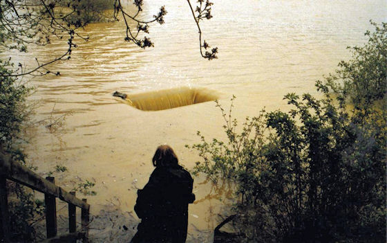
And this is the picture when the flood defence overflows. The foreground figure is the late John Wise.
Thanks are due to Mick Cooper, Keith Sandars and Bryan Smith who provided the photos and information on this page. September 2011. Updated February 2013 with pictures of the flood defences taken by Keith Sandars and February 2014 with pictures from Bryan Smith.